Written by Fumiaki Ogawa and Thomas Spengler from the Bjerknes Centre for Climate Research and the Geophysical Institute at the University of Bergen.
Understanding air-sea heat exchange is key to comprehending our global climate system. We show that the often-employed view using climatological mean temperature and wind fields to characterize this exchange only holds for tropical and subtropical regions. In the mid and higher latitudes, however, the climatological air-sea heat exchange is mostly attributable to weather phenomena on sub-weekly scales.

The atmosphere and ocean exchange energy through surface latent and sensible heat fluxes. The largest amounts of this exchange are observed in the subtropics and along the western boundary currents in the midlatitudes as well as adjacent to the sea ice edge in the high latitudes.
Surface sensible or latent heat fluxes are proportional to the product of the near-surface wind speed and the difference in temperature or humidity between the surface and the overlying atmosphere, respectively. As the climatological-mean heat fluxes are remarkably well described when using the climatological-mean wind components in the bulk flux formulas, previous studies employed steady-state and linear thinking to describe the atmospheric response to sea surface temperature anomalies and fronts.

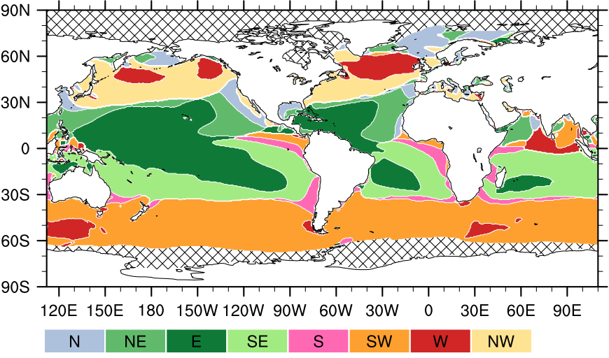
We find, that the mean wind in the lower latitudes is indeed well described by the mean westward wind components (green shading in the figure above). In the mid and high latitudes, however, a significant fraction of the climatological-mean wind speed is associated with wind variations on synoptic time scales. The prevailing wind direction associated with the most intense upward heat flux in the midlatitudes thus features a significant equatorward wind component (yellow/orange shading in the left panel), which is in contrast to the climatological mean eastward wind direction in the midlatitude (red shading in the right panel).
These findings pinpoint the necessity to consider the role of sub-weekly weather phenomena, such as extratropical cyclones and cold air outbreaks in the mid and higher latitudes, to accurately describe the air–sea heat exchange in a physically consistent way.
Reference
Ogawa, F., and Spengler, T., 2019: Prevailing Surface Wind Direction during Air–Sea Heat Exchange. Journal of Climate, 32, 5601-5617 https://doi.org/10.1175/JCLI-D-18-0752.1.

