Written by Erik Kolstad, research professor at the Bjerknes Centre and NORCE and leader of the Seasonal Forecast Engine, where this was first published.
The backdrop is that many people have studied the relationship between the extent of the sea ice in the Barents and Kara Seas in autumn and the wintertime weather farther south several months later (see for example this paper by Hall and co-authors). In recent decades, lower-than-normal sea ice extent has typically been followed by lower-than-average temperatures in Europe.
On the face of it, these kinds of relationships are great, because they can be used for prediction. Other phenomena like El Niño often lead to quite predictable changes in the weather patterns in many places. The potential value of a similar relationship between sea ice and weather is huge. Yet, a crucial question is: Even if there has been a statistical relationship between two variables in the past, does that guarantee that the same relationship will be valid in the future?
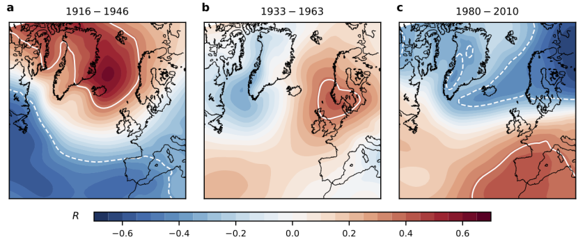
In our paper, we found that the lagged relationship between October sea ice extent in the Barents/Kara Seas and the North Atlantic Oscillation in winter (December to February) has changed a lot over time. To illustrate this, we made this figure:

During the first period starting in 1916, the correlation between sea ice and pressure is positive over the Northeast Atlantic and negative farther south. This means that below-normal sea ice cover in autumn was generally followed by westerly winds and mild and wet winter weather in Europe. But in the period between 1980 and 2010, the more familiar pattern with cold winters following low sea ice was evident. This shows how much the correlation can change over time.
The paper shows that climate models have the same fluctuations, and this led us to conclude that—as the title indicates—the relationship is non-stationary. Which again led us to “caution against indiscriminately using Barents‐Kara sea ice to predict the NAO”. We believe this has important implications for seasonal prediction.
Reference
Kolstad, E. W., & Screen, J. A. ( 2019). Nonstationary relationship between autumn Arctic sea ice and the winter North Atlantic oscillation. Geophysical Research Letters, 46. https://doi.org/10.1029/2019GL083059

