
The cones from two spotlights hit the waves a few meters ahead of the bow, elsewhere it's all dark. It is early in February, and the icebreaker "FF Kronprins Haakon" is heading westward in Fram Strait.
Along with the crew along twenty researchers are onboard. They are hoping for bad weather.
"We are here in winter for a reason," says cruise leader Kjetil Våge.
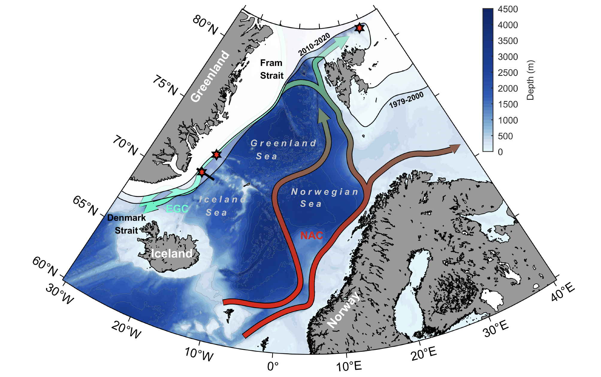
Climate change draws the ice edge closer to the coast of East Greenland, and large ocean regions are left open. The professor from the Bjerknes Centre and the Geophysical Institute at the University of Bergen wants to find out whether this may compensate for another effect of climate change, namely the weakening of the North Atlantic Meridional Circulation (AMOC).
Climate change can in theory weaken currents
The Atlantic Meridional Overturning Circulation is a like a loop where water flows northward near the surface, sinks and returns back southward at depth. The sinking is due to cooling of the water when exposed to cold, polar air. Cold water is heavier than warm water, and the cold water is mixed downward and transformed into deep water.
In climate model simulations of the future, this loop weakens, including the deep water current flowing southward and the Gulf Stream at the surface.
The main cause is an increase in precipitation and meltwater from glaciers, both contributing to building up a light and stable surface layer in the northern regions. The warm, Atlantic water from the south flows under this layer, no longer exposed to the air above. As a result, the water loses less heat to the atmosphere and does not become as dense as it used to.
Less water is transformed into deep water, so the deep water current heading south gets weaker. This is the theory, supported by climate models.
But, so far, such a weakening has not been observed. Could something have been overlooked?
Open waters change the game
Kjetil Våge's hypothesis is that loss of sea ice to the east of Greenland may counteract the effects of less dense transformation elsewhere. Right there, over the continental slope of Greenland, leads and open waters may have more substantial consequences than in most other regions.
To understand why, we must follow the current from the Atlantic Ocean.
Most of the warm water from the Gulf Stream enters the Nordic Seas on the eastern side, between Iceland and Scotland. The current continues northward along the coast of Norway and Spitsbergen before turning westward in Fram Strait, between Svalbard and Greenland. Merging with a branch that has made a turn into the Arctic Ocean, this water continues southward along the coast of Greenland, as the East Greenland Current.
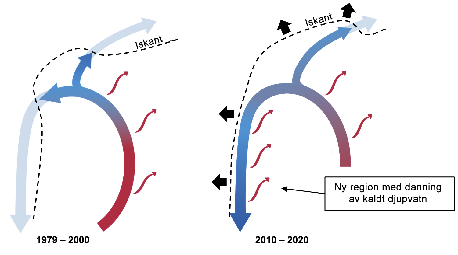
Less cooling in the east, more in the west
The water has cooled all along the route through the Nordic Seas, but so far most of the cooling has taken place in the Norwegian Sea, before reaching Fram Strait. The East Greenland Current has lied under a protecting lid of sea ice, just inside the ice edge off Greenland.
As the ice edge withdraws closer to the coast, long stretches of the East Greenland Current are exposed at once.
This way, climate changes that reduce the transformation of water in the Norwegian Sea, open up large regions at the continental slope of Greenland to deep water formation.
The East Greenland Current leads directly into Denmark Strait, where water cascades down the slope to the bottom of the Atlantic Ocean. If the ocean off Greenland turns out to deliver more deep water than before, the overturning circulation in the Atlantic may be more stable than assumed.
Most important in winter
Till now, researchers have lacked data for evaluating this hypothesis. The water cools most strongly in winter, and deep water forms exclusively during the cold season.
Research cruises in the Greenland Sea are seldom planned for the winter season, and in much of the region where "FF Kronprins Haakon" is heading, measurements have only been performed during summer.
"These regions used to be inaccessible," says Kjetil Våge.
To obtain measurement data from the sea off East Greenland, you must either have an icebreaker or stay outside the ice edge
"Now waters that were previously covered with ice, are open, and we have an icebreaker. We can go all the way onto the shelf and get the measurements we need," Våge says.
Hoping for strong winds
The stronger the wind and the colder the air, the more the surface waters are cooled, and the more deep water is formed.
The strongest cooling occurs when cold, dry, polar air crosses the ice edge and blows out over open waters. Such outbreaks of cold air are exactly the kind of bad weather the researchers hope to experience in the Greenland Sea.
To the south, a low pressure center is building up. The weather forecast looks promising for researchers wishing for rough seas and stirred waters.
Five weeks of winter await before they have to return the icebreaker.