"Frustrating," says Andreas Klocker.
The researcher from NORCE and the Bjerknes Centre refers to a question that repeatedly turns up in the media: Can climate change make the Gulf Stream stop?
"It will not," Klocker reassures us. "The winds and the Earth's rotation will keep the current going."
Still, he says, this surface current has drivers that scientists do not yet understand. What the media refer to is whether the system linking the Gulf Stream and currents in the deep ocean, could suddenly collapse – a controversial question, also among researchers.
In an article in the popular science magazine Physics Today Klocker, together with Bishakdatta Gayen from the University of Melbourne, has dived into the Atlantic Ocean. To explore complicated processes, they have chosen simple experiments.

The surface is just the surface
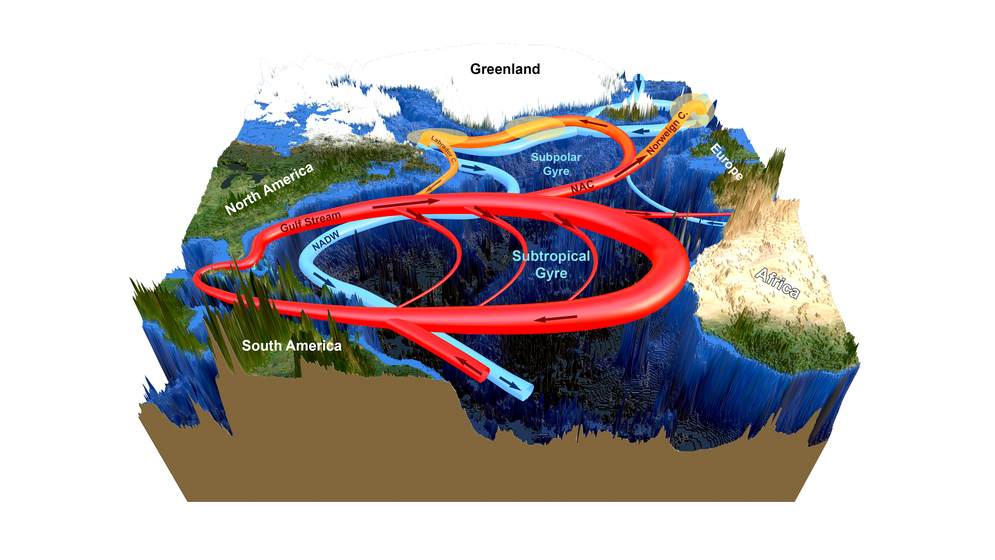
In the North Atlantic, surface water flows northward in the Gulf Stream, the North Atlantic Current and the Norwegian Current. In the north, the water cools, sinks and returns south through the deep ocean.
Both the winds and the sinking contributes to driving this conveyor belt of sea water.
When scientists discuss whether the Gulf Stream and the overturning circulation are affected by climate change, the question is usually whether higher temperatures and fresher surface waters in the north can reduce the sinking. If so, the surface currents would also be weaker.
"Those who believe the current will suddenly shut down, are a minority," Andreas Klocker says.
Nevertheless, the disagreement within the research community is a sign of an incomplete understanding of the drivers behind the overturning circulation. All climate models agree that the downwelling in the north will weaken, though at the same time struggle to simulate the overturning in the past.
Andreas Klocker emphasizes the need to find out exactly what goes on in the north.
Why does the water sink in these regions, and how does the sinking water make water flow in from the south?
A model world
Advanced climate models contain continents and a bathymetry resembling the real world. With such models you can simulate global ocean currents. An indicator of sinking water may be how deep surface waters are mixed down into deeper waters.
The figure below compares the depth of this mixed layer in winter (left) with the maximum depth of mixing (right).
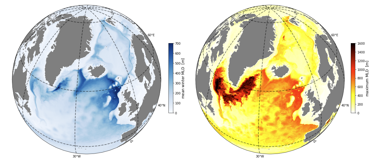
Even though the water is most efficiently mixed in the Labrador Sea, southwest of Greenland, the map to the left indicates that more of the sinking that carries heat and CO2 downward, occurs farther east, closer to Iceland, Great Britain and Ireland.
The downside of these complex models, is that paths may be hard to track. With so many factors accounted for, the cause of a single process or change is sometimes difficult to distinguish. The maps show water sinking and mixing in two regions, but not what lies behind the difference.
An Atlantic in the aquarium
To explore the cooling and sinking of water, Andreas Klocker and Bishakdatta Gayen have picked up a simpler tool: an aquarium and a computer model of the aquarium.
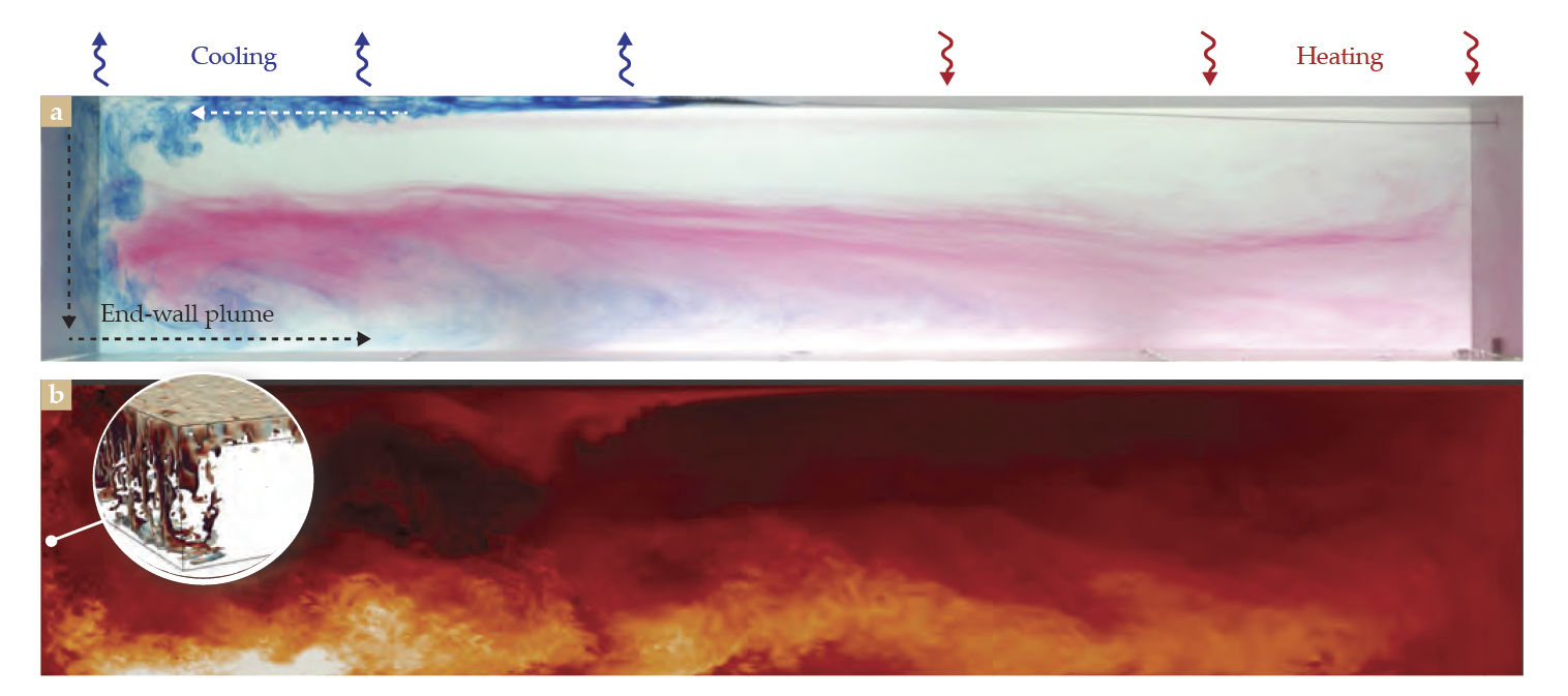
The aquarium, shown in the upper panel, is a simplified Atlantic Ocean. The cold north is located in the left end and the Tropics to the right. When dark blue, cold water hits the northern wall, it sinks. The downwelling makes water flow in from the south, while water that reaches the bottom, returns southward.
The lower model shows a computer simulation of the same, simplified ocean. The model makes it possible to study turbulent eddies and other details more closely.
In the movie below you can see how the water moves.
Let the Earth spin!
One important detail separates the aquarium from the real world. The Earth spins. The rotation of the Earth deflects moving water – to the right in the Northern Hemisphere and to the left in the Southern Hemisphere.
If the world had not turned, the Gulf Stream would not have turned east from the coast of North America and out into the Atlantic Ocean. The Earth's rotation lies behind both ocean wide gyres and smaller eddies within the current.
A simplified model was also used to make the figure below, though this model includes the effect of the Earth's rotation. The result is a whirling current crossing the ocean from west to east, not that different from the current crossing the Atlantic Ocean.
In the northeastern corner water hits the wall and sinks, some of it all the way to the ocean floor.
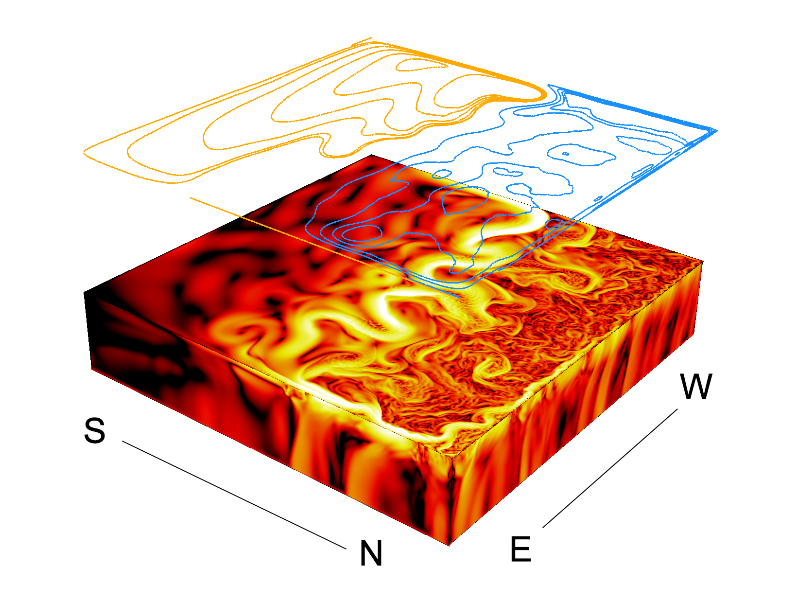
Water that has crossed the Atlantic, sinks when meeting the European continental shelf, like Klocker also observed in the blue map from the complex climate model.
"The rotation of the planet pulls the downwelling to the northeast", he says.
Sinking contributes to surface currents
The simple model contains no wind, which in reality is thought to drive much of the surface current in the Atlantic Ocean. Without the drag from the atmosphere, water still flows northward, driven by the temperature difference between the south and the north.
The experiments show that the mixing in the Labrador Sea, the coldest region, is crucial for driving the current.
"All areas are important, but in different ways," says Andreas Klocker.
With simple experiments, he and Bishakdatta Gayen have come a little closer to the small details behind powerful ocean currents.
Reference
Bishakhdatta Gayen, Andreas Klocker: Deep convection drives oceanic overturning. Physics Today 1 June 2024; 77 (6): 44–50. https://doi.org/10.1063/pt.uvlg.jjol

