Searching for navigable seas and better ice predictions
When Roald Amundsen planned his ship expedition to the North Pole, he saw no other option than sending his crew into the air to search for open leads. Though satellites make it easier to navigate through sea ice, researchers go down among the floes.
Publisert 03. June 2025
Written by Ellen Viste
Roald Amundsen testing equipment to allow him to search for leads from the air above the ship Fram. Photo: Norsk Teknisk Museum
Long swells rock the Greenland Sea. The clock is nearing midnight, and the icebreaker Kronprins Haakon has stopped. Under a crane on the deck hangs a basket with two men. The crane swings the basket over the railing, out over a carpet of ice and black leads.
Slowly the basket is lowered toward an ice floe by the ship’s side. In the basket, Anton Korosov crouches down, leans forward and places a box in the snow. He screws it into the ice and shuffles snow around its edges. Then the basket is raised, and the two are hoisted on board.
The ice flow glides out of the ship’s spotlights, disappears in the night as it should.
The box that Anton Korosov and his colleague Artem Moiseev have deployed, is a drift buoy that should follow the current southward. On the way it will send data home to the two researchers at the Bjerknes Centre and the Nansen Environmental and Remote Sensing Center.
Together with seven other drift buoys they have deployed the last week, this buoy will contribute to addressing a challenge sailors have faced for several hundred years: finding the best route through pack ice.

The buoys Anton Korosov and Artem Moiseev deployed in the Greenland Sea are about twenty centimeters in diameter. Unless destroyed, they may drift with the ice all the way to the southern tip of Greenland. Photo: Ellen Viste
Amundsen was heading north
Roald Amundsen aimed to be the first man on the North Pole, and in 1909 preparations were underway.
In the mid-1890s, Fridtjof Nansen had let the schooner Fram freeze into the pack ice north of Siberia, so that the ship could drift with the ice across the Arctic Ocean. The ship had withstood the freezing well, and now Nansen and the Norwegian state had let Amundsen borrow it for a similar expedition.
From the Bering Strait Fram would steer north, freeze in and follow the ice till it emerged through the Fram Strait. The expedition would take three to five years, long both for the men onboard and the families waiting back home in Norway. Whether Frams crew managed to find a lead that took them far enough north before the ice tightened its grip on the hull, could mean a year more or less at sea.
One must go high to see far. From the lookout barrel at the top of Fram’s mast, an observer could detect leads that could not be spotted from the deck. But even in clear weather, the view would not be much more than ten kilometers. Would it be possible to get even higher? To see the ship and the ice from above?
A forerunner of satellites
Airplanes were too expensive, Fram too small. Not even a balloon, as a German expedition had brought, would they have space for.
During the expedition Amundsen’s men would not only reach new latitudes but explore the Arctic Ocean and conquer scientific territory. Both the royal couple and the Norwegian Parliament had supported them financially. Still, resources were limited.
In spring 1909 the aviation pioneer Einar Sem-Jacobsen offered to construct something affordable and light.
Kites. Not one – a kite train.

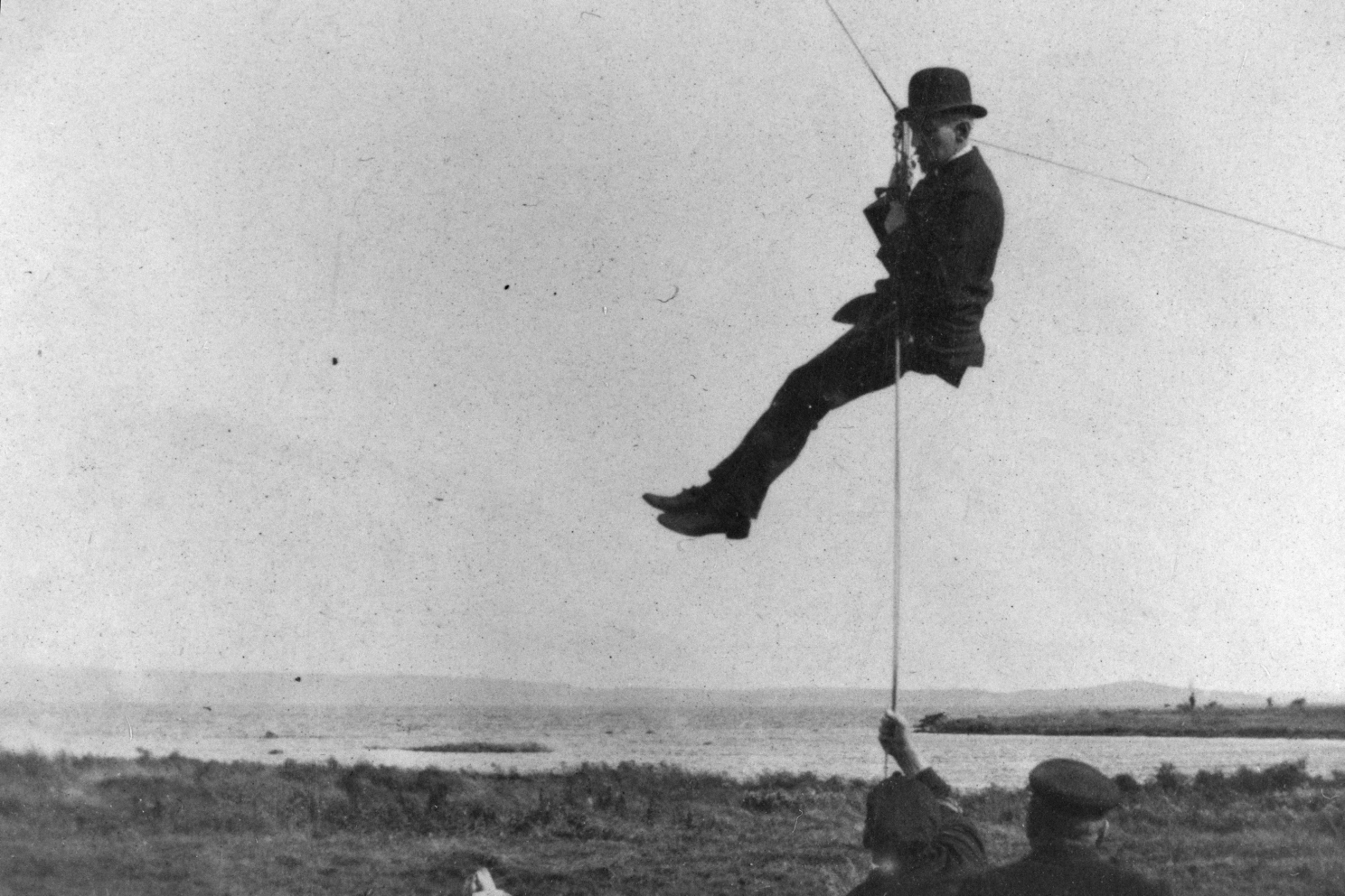
Carried by kites, high above Fram, Roald Amundsen’s crew were to look for leads in the ice. The right photo shows Amundsen himself being lowered. Photo: Norsk Teknisk Museum
Five hundred meters above Vealøs in Horten, Norway, a man floated in a canvas gondola. Above him was a small steering kite, four medium-sized lifting kites a and a large lifting kite of twenty square meters, a kite train with a common line as their only connection to the ground. A light breeze was all the kites needed to lift a man. If the wind increased to a strong breeze, two men could be raised as high.
The kite trains were tested in storms, rain and showers. «If one kite was a little unruly, the others held it back», Sem-Jacobsen writes in the book Til veirs på norske vinger. No unpredictable jerks, no sudden dives.
In September the kites where packed to be loaded onto Fram. With a view like a seagull, Amundsen’s men would be able to see ice floes and open leads far away, perhaps far enough to lead them over the North Pole.

In densely packed ice, locating leads is necessary to get anywhere. Photo: Ellen Viste
Satellites show the way
“With the ice pressing, you’re trapped as in a vice,” says Hallgeir M. Johansen, Kronprins Haakon’s captain.
He smiles from his chair. The other night we spent a full hour covering only half a nautical mile – about nine hundred meters.
“Then the first mate came on watch. After fifteen minutes, it was as if everything opened.”
The captain does not attribute all the credit to the watch change. The current was strong, the ice driftet rapidly, and with the current from the side, even an icebreaker can get stuck. If the current, the tides or the wind turns, the ice releases its grip.
“When you are in the ice, it’s as if everything is quiet,” he says, “but it’s not.”
On a screen behind him, the latest satellite image shows how currents and large eddies have packed the ice together in some areas, while the sea in other places is navigable between the ice floes. Together with maps showing the ice concentration, the images from space provide an overview Roald Amundsen’s men never could hope for.

Hallgeir M. Johansen from the Institute of Marine Research is the captain of RV Kronprins Haakon. Photo: Ellen Viste
Avoiding ice is no aim
Captain Johansen’s aim is not to avoid the ice, but to find a way through it. Kronprins Haakon is on a research cruise in the Greenland and Iceland Seas. From Fram Strait the icebreaker zigzags south toward Iceland, back and forth across the East Greenland Current, into the pack ice and back to open waters, back into the ice, back into the ocean.
A couple of days may pass between each satellite image, and the images show only the conditions at the exact time when the satellite passed. Any development since the last passage, the crew on the bridge must deduce. The ice can drift in pigtail patterns, and here and now they have to rely on the ship’s ice radar and their own eyes.
“It’s like sailing with a paper map without a GPS,” says captain Johansen.
“You have to estimate where you are relative to the ice.”
His strongest wish would be more frequent satellite images. Though in the future, computer models might make it easier to find a navigable lead between the ridges.

Satellite Synthetic-aperture Radar (SAR) is a useful tool for analyzing sea ice, as seen in this image from 8 February. The red and yellow markers show the trajectory of ice drifting buoys. The red buoy reports a significant wave height of 4.4 meters. These data can be accessed here. Credit: Ocean Virtual Laboratory
Predicting the ice cover
Anton Korosov and Artem Moiseev are out of the basket and busy analyzing data. The buoy they set out in the dark, will contribute to the development of the Nansen Center’s numerical sea ice model. At home in Bergen, model simulations are used not only to explore how sea ice forms, cracks up and floats, but also to predict the development of the sea ice cover the following days – like a weather forecast, only for ice.
Together with satellite-based radar data, the drift buoys will be used to evaluate how well the sea ice model represents the real ice. This kind of information is necessary to further develop the model and improve sea ice forecasts.
The model takes into account how ice freezes and thaws, how it is dragged by wind and currents, how it cracks up, how it piles up in ridges and where it ends up.
“As soon as this is in place in the model and in operational forecasts, it could benefit mariners, whether they’re sailing on icebreakers or on vessels that need to stay away from the ice,” says Anton Korosov.
Predictions from their sea ice model is already delivered to the EU’s Earth observation program Copernicus. The forecasts are freely available, and information from them is used when creating the ice charts that are regularly sent to ships trafficking the northern regions. But captains and mates request more detailed predictions.

Anton Korosov from the Nansen Environmental and Remote Sensing Center and the Bjerknes Center studies sea ice movements using remote sensing data and numerical models. Photo: Anton Korosov
So many things can go wrong
Cracked floes are forced to the sides of the ship as Kronprins Haakon plows through the ice. White snow slides into the ocean, while shiny blue ice comes to the surface. Earlier in the cruise, swell swung the ice 150 kilometers into the ice pack. Waves and storms can break up entire regions of ice.
What may go wrong for a small box on an ice floe? Anton Korosov and Artem Moiseev list:
“Bad batteries.”
“Frozen electronics.”
“Humidity and icing.”
“Broken by bears or seals. That has happened before.”
“Crushed between ice floes.”
There may still be hope
“As long as the buoys float, they are not lost,” says Anton Korosov.

Artem Moiseev from the Nansen Environmental and Remote Sensing Center studies ocean dynamics and interactions between the ocean and the atmosphere. Photo: Ellen Viste
May drift for several months
When they were to deploy the last buoy, the swell was too high for them to go out in the basket. No matter how advanced electronic instruments get, the real world demands dexterous hands. A buoy drop from the crane was prepared in Kronprins Haakon’s carpentry workshop.
“We took a piece of a Euro pallet and let screws stick out underneath it,” Korosov elaborates.
The buoys got its own raft, a wood floe that will carry it on if it – despise its spikes – ends up in a lead.
The batteries last for four months. With a bit of luck, that is long enough for the buoy to be tracked on its ice – or wood – floe to the southern tip of Greenland, a route that shows where and how fast ice drifts when drifting far.
While such research may make it easier for captains to find navigable leads in the future, research vessels like Kronprins Haakon will still head for the pack ice, just like polar researchers and explorers through all times have aimed for distant goals.
Amundsen lied
Amundsen did not go to the North Pole. He tricked everyone and steered Fram toward Antarctica, where the sea ice is less challenging to navigate. From the base Framheim in the Ross Sea, he headed for the South Pole with dog sleds and skis.
The kite trains never came to use. Though the need to turn people into seagulls never appeared, a small part of the equipment was valuable when more than a hundred Greenland dogs were brought ashore from Fram. Outside Framheim, the dogs were tied with a line that had once been Amundsen’s only connection to the Earth.
References
Tuning parameters of a sea ice model using machine learning
Til veirs på norske vinger
Related Projects

Resilient northern overturning in a warming climate
In ROVER the researchers will observe the deep-water formation along east Greenland, both through a winter expedition on an icebreaker, using mooring across the Greenland slope, and autonomous underwater gliders. The measurement campaign will provide groundbreaking data, cruical for the understanding of the processes that supply cold, deep water to the lower limb of the AMOC.