Mapping the world’s vanished glaciers
A global reconstruction of Ice Age mountain glaciers opens new doors for climate and ecosystem research.
Publisert 01. June 2026
Written by Suzette Flantua, Augusto Lima
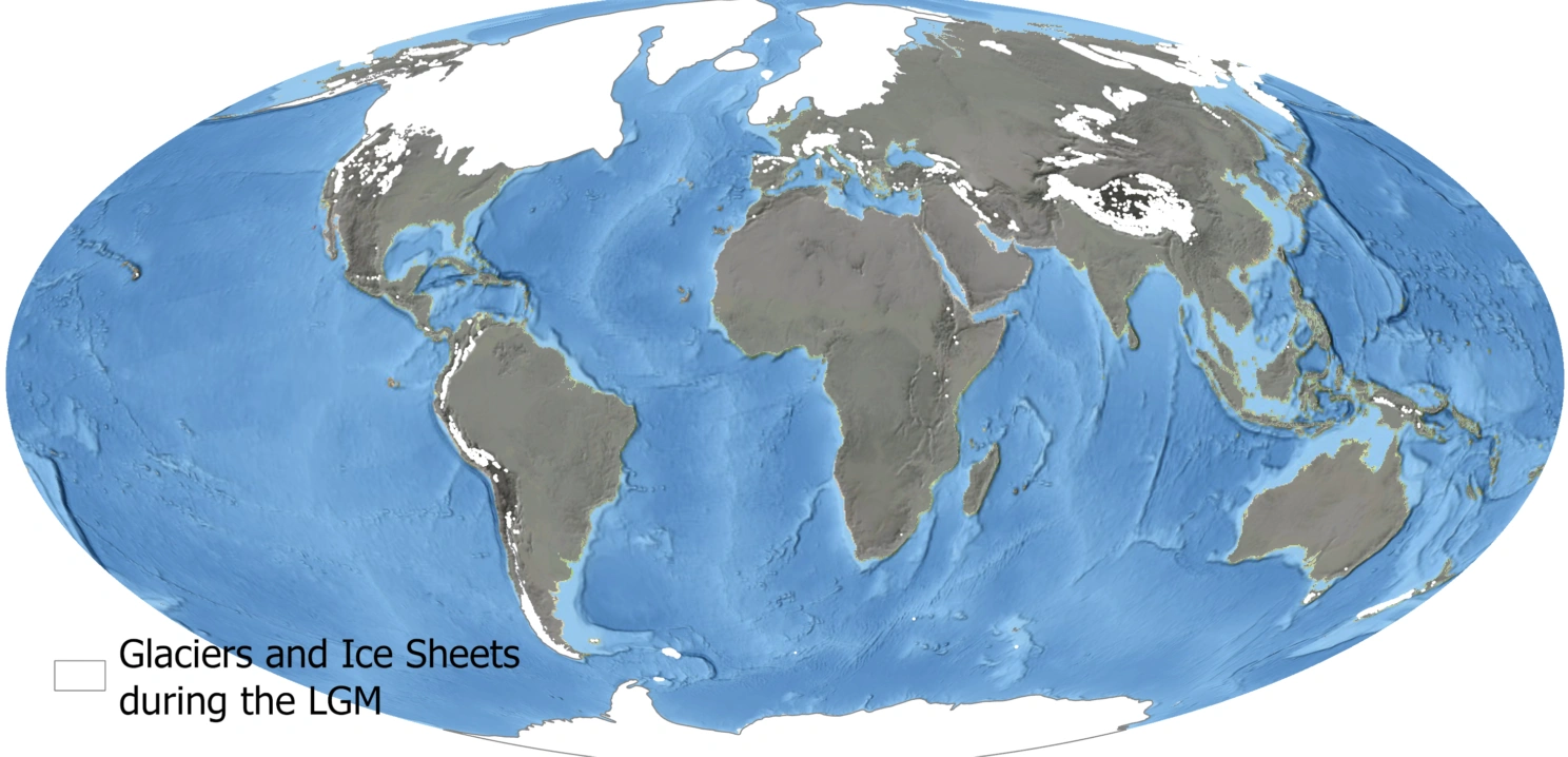
Global distribution of mountain paleoglacier extents in the GLACIMONTIS geodatabase. Credit: Lima et al., 2026 (CC BY 4.0)
Augusto Lima and Suzette Flantua are researchers affiliated with the Department of Biological Sciences at the University of Bergen; Flantua also with the Bjerknes Centre.
Around 21,000 years ago, during the coldest phase of the last Ice Age, glaciers stretched far beyond the mountain valleys we know today. In many mountain regions, ice dominated entire landscapes for thousands of years. But despite decades of research, information about these ancient glaciers has remained scattered across hundreds of local studies worldwide.
Now, an international team of researchers has brought these reconstructions together into the most comprehensive global database of mountain glacier extents during the Last Glacial Maximum (LGM): GLACIMONTIS. The study, recently published in Nature Portfolio journal Scientific Data, compiles more than 15,000 glacier reconstructions from mountain ranges across the globe.
Here we explain why reconstructing ancient glaciers matters for understanding climate, ecosystems, and the future of mountain environments.

Augusto Lima. Photo: Christian Quintana
Why study glaciers that disappeared thousands of years ago?
Modern glaciers are only small remnants of the massive ice bodies that once covered mountain regions. If we want to understand how glaciers respond to climate change, we need to look beyond the short observational period we have today.
By reconstructing glacier extents during the Last Glacial Maximum, researchers can better understand how temperature and precipitation shaped mountain glaciers under dramatically colder climates.
These ancient glaciers are like natural climate experiments. They tell us how mountain systems behaved under conditions different from today.

Suzette Flantua. Photo: Dagmar Egelkraut
A puzzle scattered across mountains worldwide
Although thousands of glacier reconstructions already existed, the information was often difficult to access or compare.
Many reconstructions were buried in regional studies, maps, or local publications. Different methods, formats, and terminology made it challenging to see the global picture.
The team compiled and standardized glacier evidence from more than 200 scientific studies worldwide. The result is GLACIMONTIS: an open-access geodatabase containing glacier outlines, chronological information, and metadata from 271 mountain ranges.
Importantly, the database also highlights regions where glacier evidence is still scarce, helping identify major knowledge gaps for future research.
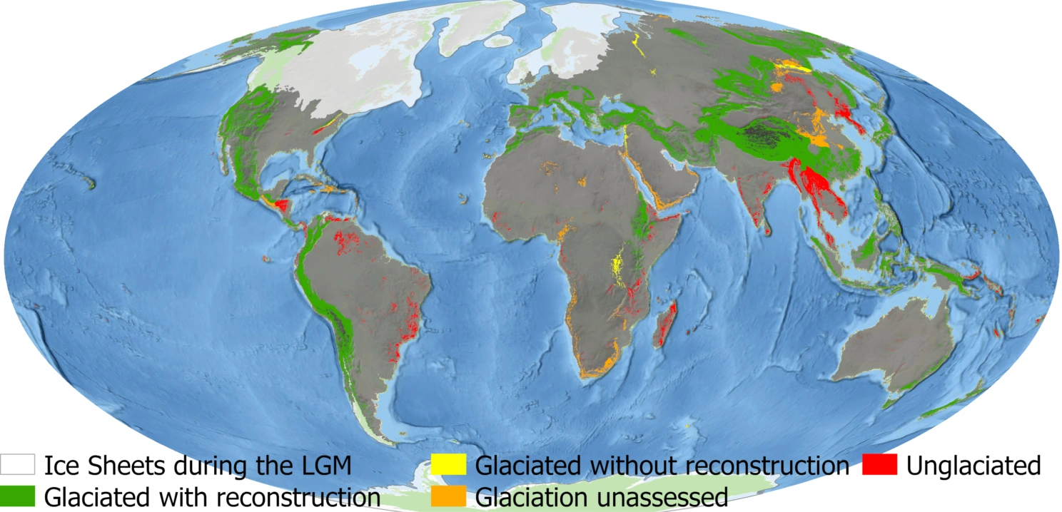
Global distribution of mountain ranges classified according to current knowledge of past glaciation and the availability of glacier reconstructions. Credit: Lima et al., 2026 (CC-BY-4.0)
More than glaciers alone
The project also connects directly to broader questions about mountain ecosystems and biodiversity.
Glaciers strongly influence where alpine ecosystems can exist. When glaciers expand, they fragment habitats. When glaciers retreat, ecosystems reconnect again. These changing mountain landscapes likely shaped biodiversity patterns over thousands of years.
The new dataset therefore provides an important foundation not only for glaciology, but also for paleoecology, climate modeling, and biodiversity research.
One of the exciting aspects is that this allows us to start integrating glaciers with ecosystems, vegetation, and biodiversity dynamics at global scales.
Mountains as archives of climate change
Mountain glaciers are among the clearest indicators of climate change today. But understanding their future requires understanding their past.
The Last Glacial Maximum represents one of the most extreme climate states Earth experienced relatively recently. By reconstructing how those glaciers were shaped by previous changes in temperature and precipitation, we gain insight into how sensitive mountain systems are to future changes in temperature and precipitation.
The project is also an example of how large international collaborations are becoming increasingly important in Earth system science.
No single researcher could compile this alone. Mountain science is inherently global. Glaciers in the Andes, Alps, Himalayas, or East Africa may differ enormously, but together they help us understand how Earth’s climate system operates across regions and timescales.
The GLACIMONTIS database is openly available and intended as a resource for researchers worldwide.
References
Mountain glacier extents at the Last Glacial Maximum